Hurricane Lee poised to bring big waves to Florida beaches
- September 8, 2023
- 0 Comments
- By Story/Photos By SurfGuru
Hurricane Lee is currently cruising through the Atlantic as a powerful Cat 4 storm with winds up to 155 mph.
As of the latest Spaghetti models there is no danger of Lee making landfall in Florida, which is promising, but how close it will come is still a little uncertain. If the current projected course holds turn we could be looking at a Cat 4 Strom as it hooks north early next week. This should cause the storm to pass at a very favorable distance from us producing a well organized swell with minimal local affect from the storm’s wind fields.
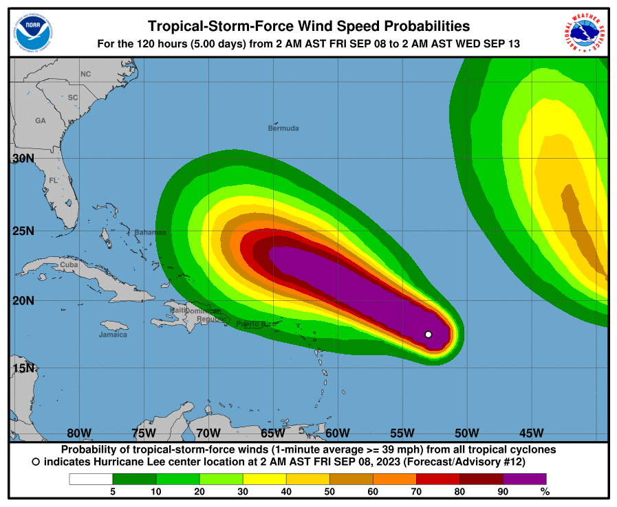
The first of Lee’s swells are expected to reach parts of the Lesser Antilles later in the day while the Bahamas, Bermuda, British and US Virgin Islands, Caicos, Hispaniola, Puerto Rico, and the Turks will see it arrive later this weekend. Florida may start to see the first signs of the swell as early as Sunday evening into Monday early am. After that, the swell should build steadily with peak days on Thursday to Friday and leftovers well into the weekend.
As always this type of swell can be well overhead so if you decide to paddle out, stay safe.
With an anticipated “more active than normal” Hurricane Season we are poised to see more of these powerful storms both in the Atlantic and in the Gulf well into November.
.gif.aspx "Lee_9-8-23s-(1).gif")
The Official bulletin from NOAH
BULLETIN
Hurricane Lee Advisory Number 12
NWS National Hurricane Center Miami FL AL132023
500 AM AST Fri Sep 08 2023
...POWERFUL CATEGORY 5 LEE EXPECTED TO MAINTAIN ITS INTENSITY...
...DANGEROUS BEACH CONDITIONS EXPECTED TO DEVELOP AROUND THE
WESTERN ATLANTIC THROUGH EARLY NEXT WEEK...
SUMMARY OF 500 AM AST...0900 UTC...INFORMATION
----------------------------------------------
LOCATION...17.8N 53.5W
ABOUT 630 MI...1015 KM E OF THE NORTHERN LEEWARD ISLANDS
MAXIMUM SUSTAINED WINDS...165 MPH...270 KM/H
PRESENT MOVEMENT...WNW OR 295 DEGREES AT 14 MPH...22 KM/H
MINIMUM CENTRAL PRESSURE...926 MB...27.35 INCHES
WATCHES AND WARNINGS
--------------------
There are no coastal watches or warnings in effect.
DISCUSSION AND OUTLOOK
----------------------
At 500 AM AST (0900 UTC), the center of Hurricane Lee was located
near latitude 17.8 North, longitude 53.5 West. Lee is moving toward
the west-northwest near 14 mph (22 km/h) and this motion is
expected to continue through early next week with a significant
decrease in forward speed. On the forecast track, Lee is expected
to pass well to the north of the northern Leeward Islands, the
Virgin Islands, and Puerto Rico over the weekend and into early
next week.
Maximum sustained winds based on data from the Air Force Reserve
Hurricane Hunter aircraft have increased to near 165 mph (270
km/h) with higher gusts. Lee is a category 5 hurricane on the
Saffir-Simpson Hurricane Wind Scale. Additional strengthening is
forecast today. Fluctuations in intensity are likely over the next
few days, but Lee is expected to remain a major hurricane through
early next week.
Hurricane-force winds extend outward up to 45 miles (75 km) from the
center and tropical-storm-force winds extend outward up to 140 miles
(220 km).
The estimated minimum central pressure is 926 mb (27.35 inches).
HAZARDS AFFECTING LAND
----------------------
Key messages for Lee can be found in the Tropical Cyclone Discussion
under AWIPS header MIATCDAT3 and WMO header WTNT43 KNHC and on the
web at hurricanes.gov/text/MIATCDAT3.shtml
SURF: Swells generated by Lee are expected to reach portions of the
Lesser Antilles later today, and reach the British and U.S. Virgin
Islands, Puerto Rico, Hispaniola, the Turks and Caicos Islands, the
Bahamas, and Bermuda this weekend. These swells are likely to cause
life-threatening surf and rip current conditions. Dangerous surf and
rip currents are expected to begin along most of the U.S. East Coast
beginning Sunday. Please consult products from your local weather
office.